The HUNGARIAN VILLAGE
FINDER, ATLAS, and GAZETTEER for the KINGDOM of HUNGARY (HVF)-
available for DOWNLOAD
or on CD-ROM, lists and provides
information for
ALL of the following towns, villages,
cities, places, settlements, and place
names associated with Csanad
County - megye - varmegye located in the old Austria-Hungary or
Austro-Hungarian Empire, now in Hungary and Romania.
Notes--Smaller
places such as pusztas and many other variations in a town's spelling
or name are not listed here, however, they, along with current place names
can all be found in the HVF...
software program.
While the place names in the following table have had all
accents and special letters removed for simplication in web site
searching, the HVF... software
program offers several methods of researching
place names including with or without the proper accents. (Hint) Learning and using the proper spelling of
place names, including the use of special letters or letters with
accents, can be key to your success in searching the internet for
websites related to the place of interest.
-
ABOUT
-
the
HUNGARIAN VILLAGE FINDER,
ATLAS, and GAZETTEER
for the
KINGDOM
of HUNGARY

INDEX
for the

Atlas, and Gazetteer for the
Kingdom of Hungary
(see what the HVF offers...)
MAPS
Find the location of your village or town in seconds with the
Hungarian Village Finder...
View EXAMPLE
pages

from the
Hungarian Village Finder...
software program
How the HVF can help with
your genealogy research
QUESTIONS

regarding the HVF...
ORDER

GUESTBOOK
Read what others say about the
HUNGARIAN VILLAGE FINDER,
ATLAS, and GAZETTEER
for the
KINGDOM of HUNGARY
or add your own comments
HOME
|
Battonya Jaras
Csanad Megye
Csanad Varmegye
Kovacshaza Jaras
Kozpont Jaras
Nagylak Jaras
Alberti
Ambrozfalva
Apacza
Apatfalva
Battonya
Csanadalberti
Csanadapaca
Csanadpalota
Dombegyhaz
Dombiratos
Dorobanti
Foldeak
Kevermes
Kiralyhegyes
Kisiratos
Kiskiralyhegyes
Kovegy
Kun-Agota
Kun Agota
Kunagota
Lele
Magyarbanhegyes
Magyarcsanad
Magyar-Dombegyhaza
Mako
Marcibanyi-Dombegyhaza
Marcibanyi Dombegyhaza
Marcibanyidombegyhaza
Maroslele
Mattenkloi-Dombegyhaza
Mattenkloi Dombegyhaza
Mattenkloidombegyhaza
Mezohegyes
Mezokovacshaza
Nadlak
Nagybanhegyes
Nagyer
Nagykovacshaza
Nagylak
Nagymajlath
Pitvaros
Puspoklele
Reformatus-Dombegyhaza
Reformatus Dombegyhaza
Reformatusdombegyhaza
Reformatuskovacshaza
Sajteny
Seitin
Tornya
Totbanhegyes
Totkovacshaza
Turnu
Vegegyhaza
|
|
|
Based on the 1877
Hungarian Gazetteer "Magyarorszag Helysegnevtara" by Janos Dvorzsak, the
HUNGARIAN VILLAGE FINDER,
ATLAS, and GAZETTER for the KINGDOM of HUNGARY CD-ROM—
Is a comprehensive dictionary, encyclopedia, atlas, gazetteer, and
directory with indexes of placenames for villages, settlements, towns,
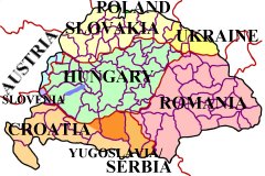
communities, and cities in the former Kingdom of Hungary (pre 1918),
including those now located in Austria, Croatia, Hungary, Poland,
Romania, Slovakia, Slovenia, Ukraine, and Serbia / Yugoslavia.
Functions as a village finder, place locator, and town seeker when
conducting a place name search.
Uses official, native, conventional, variant, and current names to make
finding a place of interest a more likely probability.
Allows for partial name or word searching when available records are
difficult to read and only a few letters are legible.
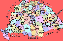
Has reference maps for
individual countries, megyes / varmegyes (counties), AND for every járás
(district) located within each county. These so-called district
maps show the location of the
villages that were once part of the Austro-Hungarian Empire!
Also includes indexed county / megye directories listing local churches
and nearby parishes (to help locate ancestor birth, marriage, and death
records), information on population and ethnicity of major inhabitants,
current country locations with names, as well as other relative
information, research aids, hints, and “Links” to online/Internet
websites.
No other resource
gives you so much in one place.
|
|