For locating
or finding towns, villages, cities, places, settlements, and place
names that were formerly in the Kingdom of Hungary, the HUNGARIAN VILLAGE
FINDER, ATLAS, and GAZETTEER for the KINGDOM of HUNGARY (HVF)-
available for DOWNLOAD
or on CD-ROM, has reference
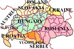
maps for individual
countries, counties (megyes / varmegyes), AND for every
district (járás)
located within each county.
(Screen
shot examples from the Hungarian Village Finder...)
- Countries -
- Counties (megye/vármegye) -
See a list of the 71
counties (megyes/varmegyes)
covered in the
Hungarian Village Finder…
- District (járás) -
with place names
- Including online (Internet) links to -
Magyar Elektronikus Konyvtar
Magyar Elektronikus Konyvtar
HUNGARIAN VILLAGE
FINDER, ATLAS, and GAZETTEER for the KINGDOM of HUNGARY —
Is a comprehensive dictionary, encyclopedia, atlas, gazetteer, and
directory with indexes of placenames for villages, settlements, towns,
communities, and cities in the former Kingdom of Hungary (pre 1918),
including those now located in Austria, Croatia, Hungary, Poland,
Romania, Slovakia, Slovenia, Ukraine, and Serbia / Yugoslavia.
Includes place names located in
the areas or regions commonly known as, or referred to as Banat,
Batschka, Burgenland, Erdeley, Kartapalja, Ruthenia, Transylvania,
Vojvodina, or Zakarpattia.
Functions as a village finder, place locator, and town seeker when
conducting a place name search.
Uses official, native, conventional, variant, and current names to make
finding a place of interest a more likely probability.
Allows for partial name or word searching when available records are
difficult to read and only a few letters are legible.
Has reference maps for
individual countries, megyes / varmegyes (counties), AND for every járás
(district) located within each county. These so-called district
maps show the location of the
villages that were once part of the Austro-Hungarian Empire!
Also includes indexed county / megye directories listing local churches
and nearby parishes (to help locate ancestor birth, marriage, and death
records), information on population and ethnicity of major inhabitants,
current country locations with names, as well as other relative
information, research aids, hints, and “Links” to online/Internet
websites.
No other resource
gives you so much in one place.
|
|