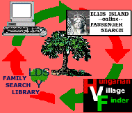
The HUNGARIAN VILLAGE
FINDER, ATLAS, and GAZETTEER for the KINGDOM of HUNGARY (HVF)-
available for DOWNLOAD
or on CD-ROM, lists and provides
information for
ALL of the following towns, villages,
cities, places, settlements, and place
names associated with Ugocsa
County - megye - varmegye located in the
old Austria-Hungary or
Austro-Hungarian Empire, now in Romania
and Ukraine.
Notes--Smaller
places such as pusztas and many other variations in a town's spelling
or name are not listed here, however, they, along with current place
names can all be found in the HVF...
software program.
While the place names in the following table have had all
accents and special letters removed for simplication in web site
searching, the HVF... software
program offers several methods of researching
place names including with or without the proper accents. (Hint) Learning and using the proper spelling of
place names, including the use of special letters or letters with
accents, can be key to your success in searching the internet for
websites related to the place of interest.
-
ABOUT
-
the
HUNGARIAN VILLAGE FINDER,
ATLAS, and GAZETTEER
for the
KINGDOM
of HUNGARY

INDEX
for the

Atlas, and Gazetteer for the
Kingdom of Hungary
(see what the HVF offers...)
MAPS
Find the location of your village or town in seconds with the
Hungarian Village Finder...
View EXAMPLE
pages

from the
Hungarian Village Finder...
software program
How the HVF can help with
your genealogy research
QUESTIONS

regarding the HVF...
ORDER

GUESTBOOK
Read what others say about the
HUNGARIAN VILLAGE FINDER,
ATLAS, and GAZETTEER
for the
KINGDOM of HUNGARY
or add your own comments
HOME
|
Tiszaninnen Jaras
Tiszantul Jaras
Ugocsa Megye
Ugocsa Varmegye
Akli
Alsohomloc
Alsokaraszlo
Alsosarad
Alsoveresmart
Avaspatak
Babony
Batar
Batarcs
Bocsko
Bokeny
Borzhavske
Bratovo
Bukove
Chepa
Cherna
Chornotysiv
Chornyi Potik
Cidreag
Csarnato
Csedreg
Csepe
Csoma
Csomafalva
Dabolcz
Diakovo
Dibrivka
Diula
Divychne
Dobolt
Drotyntsi
Dubroka
Egres
Fakobukk
Fanchykovo
Fancsika
Farkasfalva
Fedorove
Feketeardo
Feketepatak
Felsohomloc
Felsokaraszlo
Felsosarad
Felsoveresmart
Fertosalmas
Forgolany
Gherta Mare
Gherta Mica
Godenyhaza
Gyakovo
Gyivicsne
Gyula
Halmeu
Halmi
Heteni
Hetinya
Hetynia
Holmovec
Homloc
Horbki
Hreblia
Hudia
Hugya
Ilonokujfalu
Karacsfalva
Karacsin
Khyzha
Kiralyhaza
Kisbabony
|
Kiscsongova
Kisgercze
Kiskupany
Kisrakoc
Kisrakocz
Kistarna
Klinove
Kokenyesd
Kokonyosd
Komlos-Sello
Komlos Sello
Korolevo
Korolevo nad Tisou
Kryva
Magyarkomjath
Mala Kopania
Malyi Rakovets
Matiiovo
Matyfalva
Nagycsongova
Nagygercze
Nagykomjath
Nagyrakoc
Nagyrakocz
Nagyszollos
Nagytarna
Nevetlenfalu
Nove Selo
Novoselytsia
Novoszelicja
Nyzhnie Bolotne
Oleshnyk
Olyvos
Onok
Perekhrestia
Perekhrestia
Peterfalva
Petrovo
Pidvynohradiv
Porumbesti
Rakasz
Rakospatak
Rokosovo
Rosztoka
Roztoka
Salank
Sasovo
Sasvar
Shalanky
Shyroke
Sirlau
Sosfalu
Sosujfalu
Szarazpatak
Szaszfalu
Szaszovo
Szirma
Szollosegres
Szollosrosztoka
Szollosvegardos
Szolosgyula
Tamaseni
Tamasvaralja
Tarna Mare
Tekehaza
Tekovo
Tiszabokeny
Tiszafarkasfalva
Tiszaheteny
Tiszakeresztur
Tisza-Kirva
Tisza Kirva
Tiszakirva
Tiszapeterfalva
|
Tiszasasvar
Tiszaszaszfalu
Tiszaszirma
Tiszaujhely
Tiszaujlak
Tivadar
Tivadarfalva
Tolgyesfalva
Trosznik
Turc
Turcz
Turt
Turterebes
Turulung
Ugocsakomlos
Valea Seaca
Vegardoszollos
Velete
Veliki Komjati
Velyka Kopania
Velyki Komiaty
Velykyi Rakovets
Verboc
Verbocz
Verbovets
Verece
Verecze
Veresmart
Veriatsia
Vilkhivka
Vovcsanszke
Vynohradiv
Zabolottia
Zarichia
Zatiszivka
Zavadka
Zavidovo
|
Based on the 1877
Hungarian Gazetteer "Magyarorszag Helysegnevtara" by Janos Dvorzsak, the
HUNGARIAN VILLAGE FINDER,
ATLAS, and GAZETTER for the KINGDOM of HUNGARY CD-ROM—
Is a comprehensive dictionary, encyclopedia, atlas, gazetteer, and
directory with indexes of placenames for villages, settlements, towns,
communities, and cities in the former Kingdom of Hungary (pre 1918),
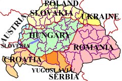
including those now located in Austria, Croatia, Hungary, Poland,
Romania, Slovakia, Slovenia, Ukraine, and Serbia / Yugoslavia.
Functions as a village finder, place locator, and town seeker when
conducting a place name search.
Uses official, native, conventional, variant, and current names to make
finding a place of interest a more likely probability.
Allows for partial name or word searching when available records are
difficult to read and only a few letters are legible.
Has reference maps for
individual countries, megyes / varmegyes (counties), AND for every járás
(district) located within each county. These so-called district
maps show the location of the
villages that were once part of the Austro-Hungarian Empire!
Also includes indexed county / megye directories listing local churches
and nearby parishes (to help locate ancestor birth, marriage, and death
records), information on population and ethnicity of major inhabitants,
current country locations with names, as well as other relative
information, research aids, hints, and “Links” to online/Internet
websites.
No other resource
gives you so much in one place.
|
|